The Complete Guide to Backpacking Cottonwood and Marble Canyon
Winter hits and you’re craving a backpacking trip that’s not buried deep in snow. Cottonwood and Marble Canyon loop is located in Death Valley National Park and is the perfect choice. Death Valley is located in the California desert and is known for its extremely high temperatures, making this trail ideal for colder months. The approximately 31-mile loop consists of dramatic canyons, vast desertscapes, steep ridge lines, and beautiful rock formations. It’s an epic trek but does require planning as water sources are scarce and navigation isn’t easy.
DETAILS
Where: Death Valley National Park
Distance: 31 miles
Days: 3-4 days
Elevation: 5,617 ft. (peak elevation = 5,059 ft.)
Difficulty: Strenuous
Time of year: Winter, late fall, or early spring
Permit: Yes
WHEN TO GO
If you didn’t already know, Death Valley is hot. Very, very hot. Along with high temperatures, this trail is extremely exposed with little areas of shade. Therefore, winter is the best time to go.
If you choose to go in early spring, be aware of potential flash floods. Flooding can be very dangerous when heading into the narrow canyons. Always check conditions online or call a ranger station for up-to-date information prior to your trip!

PERMIT
Backcountry permits are required for this trail but are free and unlimited. You can get one at the Stovepipe Wells ranger station or online prior to your trip.
HOW TO GET THERE
Starting from the Stovepipe Wells campground, drive west on Cottonwood Canyon road. This 8.5 mile road requires a 4WD high clearance vehicle as it consists of deep sand and small boulders. Plan ahead so you don’t get stuck! Once you reach the intersection of Cottonwood Canyon road and Marble Canyon road, you have two options. You can either park in the lot here (adds two extra miles each way) OR you can drive two more miles to the actual “trailhead” and park there. The final two miles are VERY rough. We chose to hike the extra miles and save our car from any damage.

GEAR
Check out my weekend backpacking gear list for a detailed list on what to bring. Here are some extra details:
Sun protection (sunscreen, sunglasses, hat, etc) – the trail is very exposed
Water filter and extra water reservoir/dirty water bag
Electrolytes! So key to stay hydrated in the heat
GPS and/or AllTrails downloaded map – SO important; this trail can be extremely hard to navigate
WATER
As you can imagine, water availability in Death Valley is scarce. There are three seasonal water sources along the trail that MAY be flowing. They’re most reliable between December and March, but always check conditions before your trip as they can change at any time. When hiking the loop clockwise, the three springs are:
Cottonwood Canyon (11 miles in): when flowing, water is visible at the end of Cottonwood Canyon road
Cottonwood Springs (13 miles in): this is the most reliable and the only water source flowing when I went!
Deadhorse Canyon (21 miles in): normally the first water source to dry up
Although water is scarce, you should drink at least a gallon (4 liters) of water per day. I’d recommend bringing a water reservoir and/or an extra dirty water bag so that you can carry extra water. Also be sure to bring either a water filter or purification tablets!

Filtering water at Cottonwood Springs
TRAIL
The Cottonwood Marble Canyon loop is normally completed in a clockwise loop (what I did), but can also be done counter-clockwise. The trailhead is located at the junction of Cottonwood Canyon road and Marble Canyon road. You begin day one by following Cottonwood Canyon road for about 10 miles. Once the road narrows into a trail, you’ll come across the first seasonal water source (was not running when I went). This area is filled with cottonwood trees and has beautiful campsites if you choose to stop here.
As you continue on to Cottonwood Springs, the trail gets a little confusing and it’s easy to get lost. Make sure to download the map on AllTrails prior to your trip! Right before you make your way down into the grove of Cottonwoods, keep right to find a side trail down to Cottonwood Springs. Fill up on water as this is most likely your last source of water. There are a couple of beautiful campsites within the cottonwood grove and near the spring. We woke up the next morning with wild horses outside our tent! Hopefully you’re lucky and get to see them as well.

Campsite at Cottonwood Springs
Day two requires a lot of navigation and is an overall difficult day. You’ll start with a hike across desertscapes, following only footsteps in the sand for miles. After this portion, you’ll make your way up the valley. Make sure to keep the mountains on your right. You’ll eventually reach a steep gully that leads to a low saddle that allows you to cross into Deadhorse Canyon. Once you arrive at the saddle, keep right and follow the AllTrails route for a less steep descent into the canyon. You’ll see a more steep route to the left but we chose not to take this. This part is VERY confusing so make sure to have navigation of some sort. Once you finally make your way into Deadhorse Canyon, there are so many amazing campsites!

Heading into Deadhorse Canyon
On the last day, you’ll first make your way out of Deadhorse Canyon. When you reach a 8 foot drop, I’d recommend dropping or passing your bag down first then climbing down. Later on, you’ll reach another large drop that you aren’t able to go down. Climb up to your left and around to get past it.

8 foot drop prior to Marble Canyon
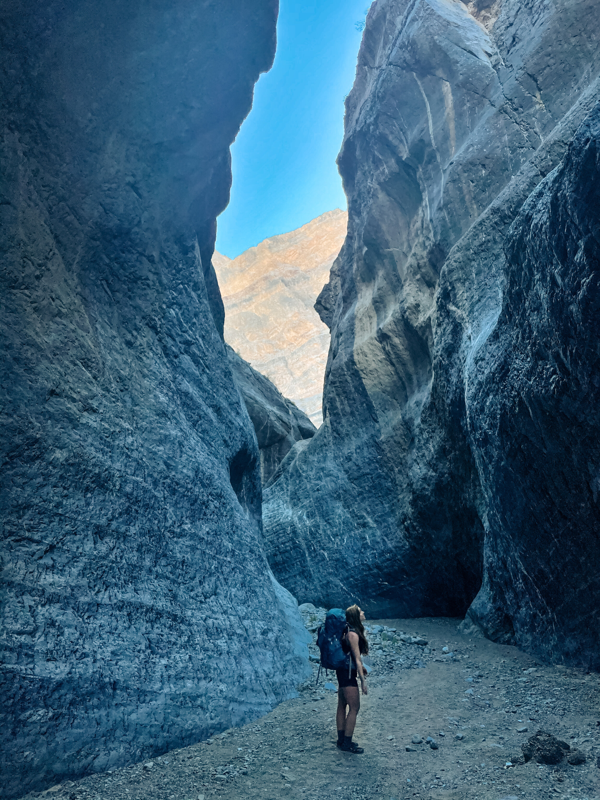
You’ll soon reach Marble Canyon which is the highlight of the entire loop. Marble canyon is filled with beautiful high canyon walls and narrow paths. The views are breathtaking around every corner. Make sure to check the weather prior to your trip as flash flooding can be very dangerous in this canyon!
After Marble Canyon, you’ll reach Marble Canyon road which you can take all the way back to the parking lot before the Cottonwood-Marble junction.
MY ITINERARY

This map shows my exact itinerary for the Cottonwood and Marble Canyon Loop. Blue (day 1), green (day 2), and purple (day 3). I chose to go clockwise but you can also go counter-clockwise.
3 DAYS CLOCKWISE
Day 1 (14 miles) - Start at parking lot two miles before Cottonwood-Marble junction. Hike clockwise to Cottonwood Springs. Camp near Cottonwood Springs and fill up on water (last reliable source)!

Approximate elevation profile of day one
Day 2 (6 miles) - Cottonwood springs to Deadhorse Canyon

Approximate elevation profile of day two
Day 3 (11 miles)
Deadhorse Canyon back around to the parking lot before Cottonwood-Marble junction. You’ll pass through Marble Canyon.

Approximate elevation profile of day three
ALTERNATIVE ITINERARIES
NOTE: All of these routes are clockwise but you CAN do them counterclockwise if you choose

2 DAYS
Day 1 (14 miles) - Start at parking lot two miles before Cottonwood-Marble junction and hike clockwise to Cottonwood Springs.
Day 2 (17 miles) - Long day so make sure to start early! Cottonwood Springs all the way around past Deadhorse Canyon and Marble Canyon before returning to your car.
3 DAYS
Day 1 (11 miles) - Start at parking lot two miles before Cottonwood-Marble junction and hike to the end of Cottonwood Canyon Road. The seasonal spring here MAY be flowing (it wasn’t when I visited).
Day 2 (9 miles) - Hike from the of Cottonwood Canyon road to Deadhorse Canyon. Make sure to fill up on water at Cottonwood Springs!
Day 3 (11 miles) - Deadhorse Canyon back around to the parking lot before Cottonwood-Marble junction. You’ll pass through Marble Canyon.
4 DAYS
Day 1 (11 miles) - Start at parking lot two miles before Cottonwood-Marble junction and hike to the end of Cottonwood Canyon Road.
Day 2 (3 miles) - Hike from the of Cottonwood Canyon road to Cottonwood Springs
Day 3 (6 miles) - Hike from Cottonwood Springs to Deadhorse Canyon
Day 4 (11 miles) - Deadhorse Canyon back around to the parking lot before Cottonwood-Marble junction. You’ll pass through Marble Canyon.
If you’re looking for an amazing winter backpacking trip, Cottonwood and Marble Canyon is the perfect option. If you have questions or would like to share how your trip goes, send me a comment!